fbpx
TEMPLATE USED:
pageid: 10706

6 Unmissable Spots to Visit on Easter Island

Visiting Easter Island is one of those once-in-a-lifetime experiences; a tiny speck of land located far out in the middle of the Pacific Ocean, a trip here is a chance to go back in time and immerse yourself in a wholly unique way of life. Known as Rapa Nui in the local indigenous language, the island has become internationally famous for its Moai: immense, human-esque rock statues that are dotted around the island. The mysteries surrounding their creation and how they were moved from place to place beguiled historians and archaeologists for years, and their size and stature mean that they have to be seen to be believed. With hiking and cycling trails, idyllic weather, sweeping oceanic vistas, endless fresh seafood, and a warm and welcoming local population who are eager to share their culture, it’s one of those destinations that has to go on your bucket list.


But even though all of Easter Island is worth exploring, there’s only so much time per trip and you want to make sure you hit all the highlights, the best that Rapa Nui has to offer. From the tips of volcanoes to pristine beaches to sacred sites, these are the 6 unmissable spots to visit on Easter Island!


Rano Raraku

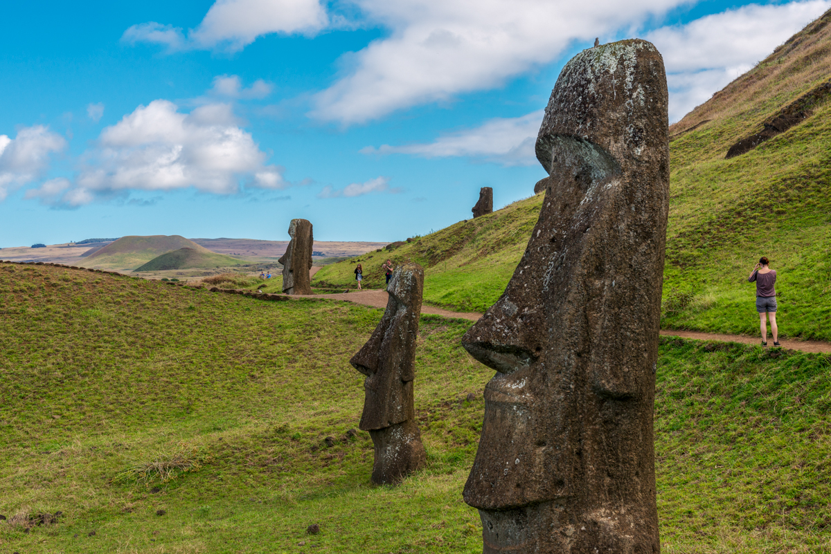
An extinct volcanic crater attached to Ma′unga Terevaka, the largest of Easter Island’s three dormant volcanoes, Rano Raraku is one of the most historically and archaeologically important sites on the entire island for one big reason: it was a Moai factory.


On the slopes of Rano Raraku, Rapa Nui islanders found a massive quarry of tuff (a type of rock made from volcanic ash). Comparatively soft and easier to carve than most other rocks, tuff was ideal for crafting Moai, so 95% of the island’s famous statues came from the Rano Raraku quarry.


Used by islanders as a source of tuff for over 500 years until the early eighteenth century, at the quarry you can see for yourself the design evolution of the Moai statues. Various incomplete Moai dot the site, as well as the surrounding hillsides. Some of the most striking differences between these Moai and the ones at sites like Ahu Tongariki include their lack of pukao tophats or the fact that several are buried up to their shoulders instead of showing the whole body. In fact, it’s actually these hillside Moai statues that are some of the most famous examples of Moai on the island: since they are buried up to the neck, it is from them that the world got the term “Easter Island Heads”, as this was before excavation revealed their subterranean bodies. With 400 Moai in and around the quarry (including one attached to the quarry wall that’s 71 feet long and weighing an estimated 200 tonnes), the discovery of Rano Raraku was key to helping the world understand how the design and creation of the Moai were carried out over time.


There are various paths running around the site that take visitors past the quarry and the “Easter Island Heads” on the hillside. You can also climb up to the rim of the crater, which now holds a freshwater lake; it’s worth the climb for the panoramic view of the island and ocean.

Ahu Tongariki

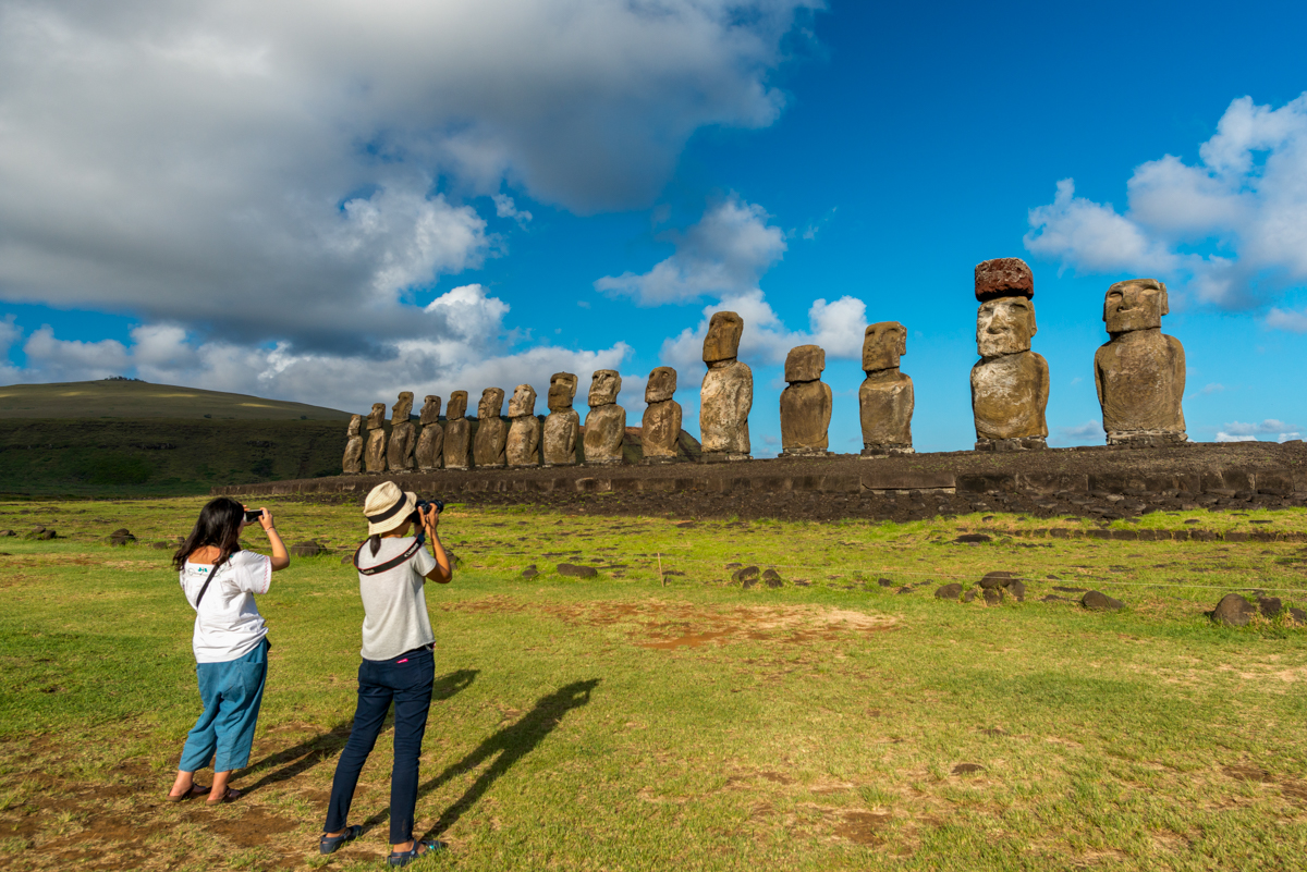
A short walk from Rano Raraku, you’ll find one of the most instantly recognizable sites of the island: the row of 15 Moai statues standing side by side with the ocean in the backdrop.


Placed on top of an ahu (a large stone platform), Ahu Tongariki is the largest ahu on Easter Island. In the past, it was the capital of Hotu Iti, an area spanning the eastern portion of the island that was governed by a clan of the same name. During the island civil wars in the late 1770s and early 1800s, the Moai were toppled off the platform (many others around the island met a similar fate). Then in 1960, an earthquake off the coast of Chile (a 9.5, the strongest ever recorded) caused a tsunami that swept the ahu and its Moai inland. It wasn’t until the 1990s that the ahu was restored to its original place and grandeur, following a five-year retrieval and renovation project.


A wonder to behold any day of the year, Ahu Tongariki is especially amazing to see during the Summer Solstice, when all the Moai face the setting sun head-on. The site is also popular for watching the sunrise over the ocean with the ahu in the foreground.

Rano Kau & Orongo 

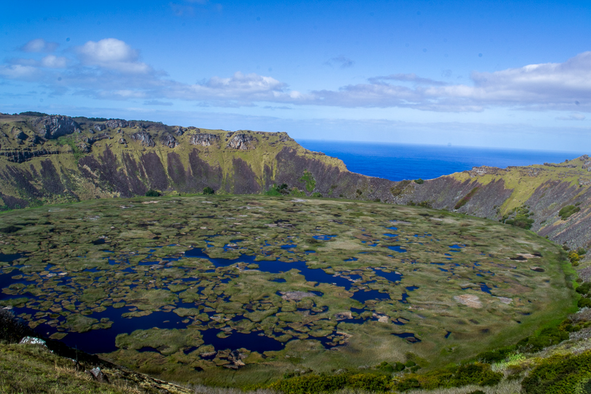
On the southwestern headland of Easter Island can be found one of the island’s most striking geographic features: the enormous crater of the Rano Kau volcano.


Rising 1,063 feet up from sea level, Rano Kau is an extinct volcanic crater (like all the other volcanoes on Easter Island), making its immense, circular crater a must-visit for views of the island, ocean, and the freshwater lake in the base of the crater. A single trail leads to the rim (a tiring but relatively easy hike), where you can take in the crater’s conical walls, the lake and surrounding vegetation, and the ocean beyond. The crater – which is more than a mile across –  is especially interesting because, thanks to the tall walls that shelter the base from winds, the crater has formed its own micro-climate; vines and figs grow especially well here. From the far end of the crater, you can also see where the outer walls of the volcano plunge down as steep sea cliffs into the Pacific Ocean.


Here, you’ll also find Orongo, a stone village that used to be an important ceremonial center. Made up of 53 circular stone houses, which were built low to the ground and without windows, Orongo was the site of one of the most spectacular and dangerous feats in Rapa Nui culture. Every year, a competition was held to bring back the first “manu tara” (sooty tern) egg of the season. The terns nested on a small island just off the coast called Motu Nui; to reach the island, contestants had to climb down the sheer volcanic sea cliffs, swim to the island, grab an egg, and then repeat the journey back up the volcano. Incredibly dangerous, many participants were killed during the race, either by falling from the cliffs, being eaten by sharks, or drowning. The man who finally emerged as the victor was dubbed the “Tangata manu” (Birdman).


Now a World Heritage Site inside Rapa Nui National Park, you can visit Orongo and see for yourself just how treacherous the race was.

Ana Te Pahu & Ahu Akivi 

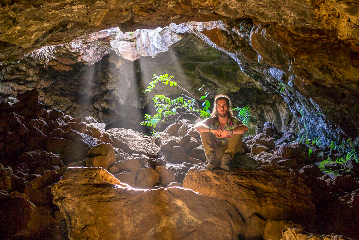
Easter Island was created more than 750,000 years ago by volcanic explosions. During its formation, flowing lava created subterranean channels all over the island, which hardened into rock and formed cavities in the earth. Ana Te Pahu (meaning “the cave of the drum”) is the largest of these volcanic caves.


Located near the base of Ma′unga Terevaka, in the past, the cave was likely used as a place of shelter, since the cave entrance is easy to access. A nearby chamber of the cave holds a water reservoir and archeologists have found evidence of ancient cooking stoves. The entrance to the cave was also surrounded by banana trees, earning Ana Te Pahu its second name “the cave of bananas”.


Visitors can explore the cave on their own, as there are rudimentary paths, but it’s recommended that they bring sturdy walking shoes and a flashlight.


Near the cave, you’ll also find one of the island’s Ahus, Ahu Akivi. Although not as well-known as Ahu Tongariki, it’s one of Rapa Nui’s most sacred sites. Erected sometime in the 16th century, the seven Moai on the ahu were believed to be the reincarnations of important leaders or kings on Easter Island, and so were built and placed facing the Pacific Ocean (instead of inland, like other ahus) as auspicious symbols of protection and luck for the clans of each Moai leader. The site was also used for astronomical observations, serving as points for precision measurement by lining up with the Spring and Autumn Equinoxes (the only Ahu on the island to do so).
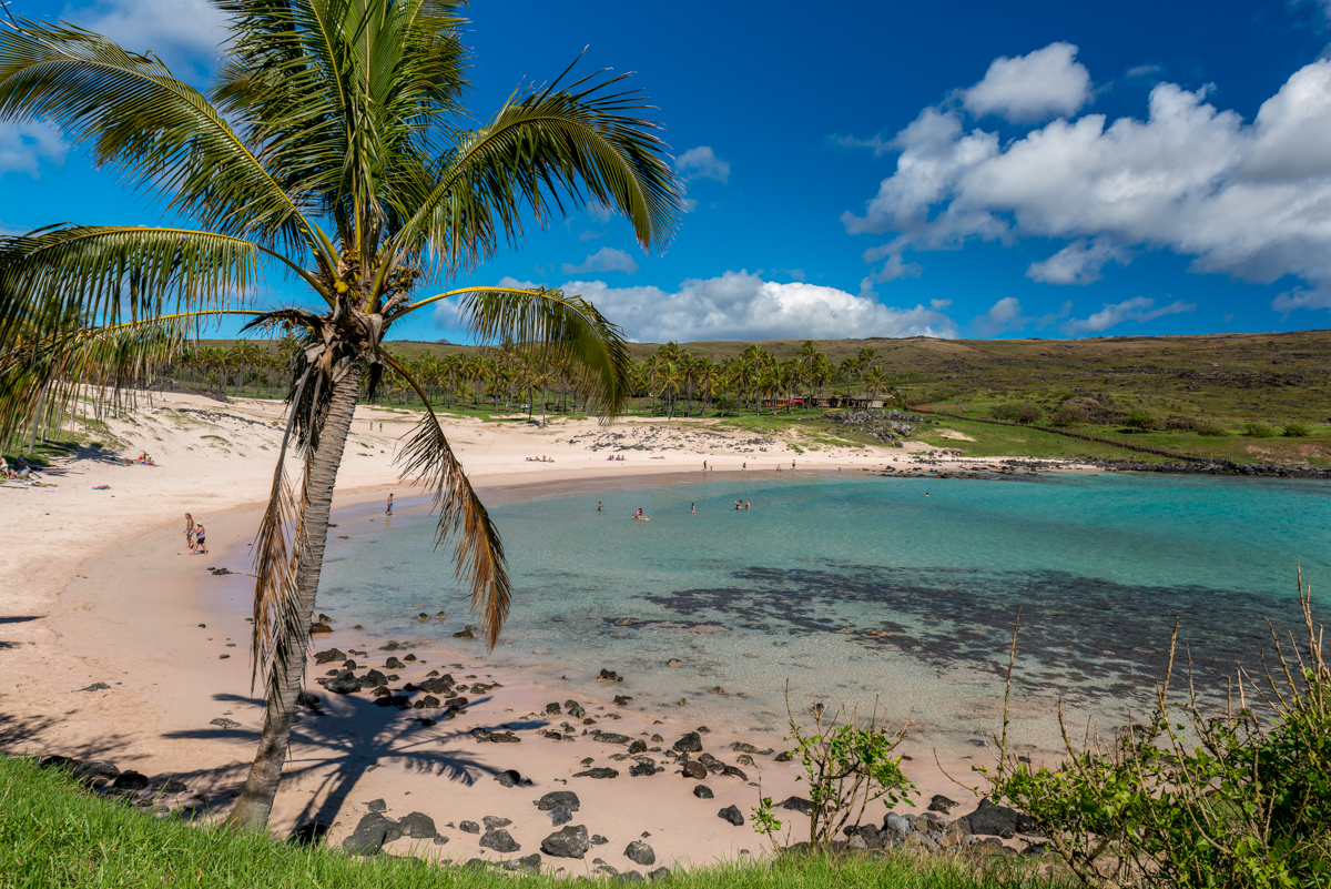
Anakena Beach 

Visitors to Easter Island primarily go to discover the island’s unique history and culture. But don’t forget that Easter Island is still a tropical island in the middle of the Pacific Ocean, with lovely weather, tranquil ocean views, and sandy beaches that are perfect for days of rest and relaxation. Anakena is the island’s main beach: a protected cove of white coral beaches, turquoise water, and waving palm trees. Idyllic and isolated, it’s the perfect spot to spend a day enjoying the sun and surf after days of cultural immersion. The water stays warm enough for swimming all year round, and there are nearby restaurants, picnic areas, and facilities for day trippers from Hanga Roa (the main town on the island).


But Anakena is more than a pretty beach: it’s actually the cradle of Rapa Nui’s culture and civilization. The first king of the island, Ariki Hotu Matu’a, landed here with his tribe and established the first colony on Easter Island, and later, the beach and surrounding lands were the home of the royal Miru tribe and an important cultural center. All this is known from the many archaeological artifacts found around the beach and nearby hills, as well as two ahu.

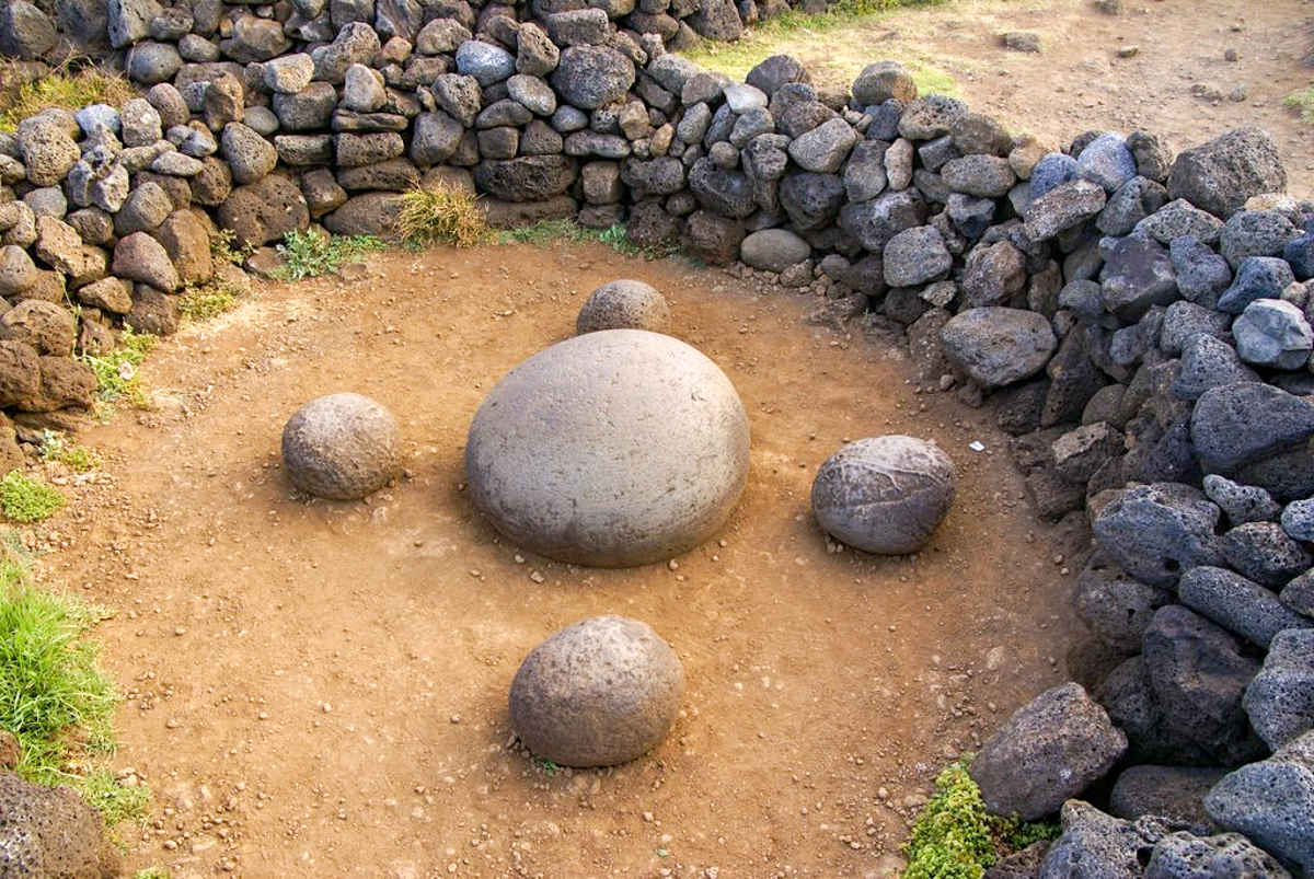
Ahu Te Pito Kura & Paro Moai 

Ahu Te Pito Kura forms part of a historic complex of buildings, strategically and symbolically located at the center of the site. The ahu has only one Moai, Paro, which was pulled down and destroyed at some point in the past (it’s believed it happened in the mid-1800s). But Paro is more important because it was the largest Moai ever made and transported on Easter Island.


Made in the Rano Raraku quarry more than 8 kilometers away, moving this behemoth statue – which weighs more than 80 tons and is 32 feet long – must have been an incredibly difficult and strenuous feat. Today, Paro lies face down where he first fell, with his pukao hat a short distance in front of him.


But the site holds other treasures, like the Magentic Stone. Legend says that this large and spherical stone was brought to Easter Island by its first king Hotu Matu’a and that it possesses special energy called “mana”, which acts as a sort of magnet. This can be explained by the presence of large quantities of iron content in the stone, causing it to heat up quickly and affect nearby compasses. In the past visitors were able to place their hands on it to try and feel the energy within, but after some inappropriate behavior, it’s no longer allowed. The stone is what gives the site its name: “The Navel of the World”.


The top things to do in the Atacama

Covering tens of thousands of miles, the Atacama, the world’s driest desert, is full of opportunities for adventure and discovery. But, with such a vast expanse of space, there are far too many things to do than you can fit into a single trip. So what are the best activities that will provide you with the ultimate Atacama experience? These are our picks for the top things to do in the Atacama!

Visit the El Tatio Geysers

Sitting over 14,000 feet high, the El Tatio Geyser field, which is comprised of eighty active geysers, is one of the highest geyser fields in the world, as well as the largest in the Southern Hemisphere and the third-largest globally. Nestled at the base of stratovolcanoes which are the source of geothermal activity, Tatio is one of the most popular sites in the Atacama. The best time to visit is in the early morning when the cold air enhances the steam rising from the geysers, resulting in dramatic plumes that cover the area in mist. And always obey the rules and stay on the path: the temperature of the water and steam reaches dangerous levels and can cause bodily harm, so never leave the marked trails. Otherwise, feel free to wander and marvel at these feats of nature!


Go stargazing

Thanks to a winning combination of extreme altitude, very little rain, and no large cities (which means there is virtually zero light pollution or radio interference), the night skies of the Atacama are some of the clearest on Earth. Many top observatories are based in the Atacama (like ALMA), using some of the most advanced telescopes on the planet to produce cutting-edge scientific breakthroughs in the field of astronomy. But you don’t need to be a scientist to appreciate the night sky here: just walk outside or drive a short distance from San Pedro and you can see the Milky Way and other celestial bodies with the naked eye. There are plenty of stargazing tours available around the Atacama, where, with the aid of professional or amateur astronomers and high-quality telescopes, you can find constellations, look for planets and moons, and much more.

Swim in a salty lagoon

Dotted throughout the salt flats that surround San Pedro are lagoons of refreshingly cool water, making them great spots to beat the heat during those high desert summers. But thanks to the location, the water in these lagoons have incredibly high levels of salt, making floating in them feel like you’re completely weightless. There are several such lagoons you can visit, like Laguna Baltinache, but Laguna Cejar is the most popular. The bright blue waters of the lagoon stand out against the stark white of the salt flats, making it both a relaxing and picturesque spot.

Watch the sunset in Valle de la Luna

Just outside San Pedro is one of the most out-of-this-world (literally) places to visit: Valle de la Luna. Meaning “Valley of the Moon”, the strange rock formations and salt-encrusted ground make the landscapes look like something you’d see on the moon. There are various driving and hiking trails around the area, all of which lead to incredible viewpoints and can be enjoyed throughout the day, but the best time to visit is at sunset, when the combination of light, shadow, and color has to be seen to be believed.

Look for native wildlife

Although the barren desert-scapes may look utterly inhospitable to life, the Atacama is full of unique wildlife that has adapted to the harsh environment. You’re bound to see vicuña (smaller, undomesticated relatives of llamas and alpacas) all over the place, as well as domesticated llamas. The Andean fox is a common sight, and when passing by heaps of rocks, you’re likely to spot vizcachas (rodents that are similar to chinchillas) sunning themselves. The birdlife in the Atacama is also extremely diverse, but one species of bird you’re guaranteed to see at the Chaxa Lagoon (roughly an hour outside of San Pedro) are bright-pink flamingos, which gather in huge flocks to feed. And if you’re really lucky and know where to look, you may even see pumas stalking herds of vicuña.

Walk around the historic town of San Pedro 

This small town of adobe buildings and dusty streets is the center of Atacama tourism, so while you’ll be spending most days heading out into the surrounding desert for adventures, it’s worth taking a day to roam San Pedro’s streets. You’ll find plenty of artisan shops, restaurants, bars, historic architecture, and museums to visit. San Pedro has a very laid-back, chill vibe, so exploring its meandering avenues, enjoying local food, and buying souvenirs is a great way to unwind after long days of exploring.

Go back in time at Pukara de Quitor

Terraced across a hillside overlooking a verdant river valley, this Pre-Columbian fort, built by the Inca in the 12th century, was used as a defensive fortress against invaders. Comprised of rooms, corridors, and lookouts made from rock and mud walls, the site is incredibly well-preserved and you can walk around it to enjoy the vistas of Licancabur Volcano on the horizon and think about the battles that were once fought here.

Mountain bike at Quebrada del Diablo

The rugged canyons and valleys of the Atacama are perfect for outdoor sports enthusiasts, especially mountain bikers. The Quebrada del Diablo (“Devil’s Throat”) dried-up riverbed is an excellent spot for it, with the trail surrounded by rock walls of bright red.


Go for a sunrise hot air balloon ride

If you thought the dramatic landscapes of the Atacama were beautiful on the ground, just imagine how they look from a bird’s eye view! At dawn, when the rising sun colors the desert in red and gold, it’s a truly awe-inspiring sight. You can book sunrise hot air balloon tours near San Pedro, which include transport to the launch site and a multilingual guide. While the balloon ride is a bit pricey, it’s well worth the cost for the unforgettable views from the balloon’s basket, passing over serene desert landscapes and with mountains and Licancabur Volcano in the distance.


6 Must-Visit Places in Patagonia

In a region as vast and rich in natural wonder as Patagonia, it can be hard to know what sites to prioritize for your visit. Everything is beautiful in its own way, from the mountains to the glaciers to the plains, so how do you choose? What are the can’t-miss places? Well, if you want to see and experience the best of what Patagonia has to offer, these are our six must-see places in Patagonia!

Base of the Torres

One of the most popular and well-known hikes and viewpoints in Torres del Paine National Park, the Torres are the three granite spires for which the park is named. Rising up from the middle of the Paine Massif, with a vividly-electric turquoise lake at their base, reaching this iconic view requires a full day hike. You start from near the Las Torres Hotel and then climb up and into the mountains via the “Paso del Viento” or Pass of the Winds. After hiking through a forest on the Ascencio valley floor, the final push comes when you climb up a rocky glacial moraine. But at the top is one of the most spectacular views anywhere in Patagonia: three pillars of rock, shaped by wind and ice, standing stark against the sky, with the lake below. Sit back, relax, and enjoy the view before climbing back down.


Grey Glacier

Another of the most popular attractions in Torres del Paine National Park is the Grey Glacier. Located on the western end of the Paine Massif, the front wall of the glacier towers over a hundred feet high, and frequent calvings litter Grey Lake with fantastically shaped icebergs in unbelievable hues of blue and white. The Grey Glacier flows out from the Southern Patagonia Icefield and, upon reaching its terminus in Grey Lake, is split by a small island in the middle of the lake. Boats and catamaran tours are able to get up close to the front wall, but you can also kayak on the lake at a safe distance from any icebergs or waves caused by calvings. You can even go on ice-hikes on the glacier itself! An amazing feat of time and nature, the size and might of Grey Glacier has to be seen to be believed.


Paine Massif

The Paine Massif (also known as the Paine Cordillera) is the mountain group that makes up the centerpiece of Torres del Paine National Park. Made of granite and other rocks that have been molded by the movements of glaciers and Patagonia’s intense weather for centuries. What’s left are impressively-shaped mountains like the Torres or the Cuernos (The Horns), two mountain peaks of light and dark rock that stand prominently at the front of the massif and are one of the park’s most recognizable landmarks. In the interior of the massif, the French Valley also features astonishing rock formations like the Sword and the Shark Fin. At all points along the W Trek and while driving around the park, you can admire the massif’s many different mountains and rock forms from all angles, each more impressive than the last. An especially good viewpoint is the Mirador Cuernos, located near the Pehoe Lake catamaran launch, and which looks upon the Cuernos and the front of the massif.


Mount Fitz Roy

The crown jewel of Argentine Patagonia’s Los Glaciares National Park, you’ll likely recognize Mount Fitz Roy – it’s the mountain on the Patagonia Clothing logo! Rising to a prominence of more than 6,000 feet, this cathedral of rock and snow can be admired on several different treks around the park, including the Fitz Roy and Cerro Torre Circuit (which reaches an elevated viewpoint of the two mountains and the glacial lakes at their base), and the Mount Fitz Roy Trek, which leads to the shores of the aquamarine Laguna de los Tres in front of the mountain. Fitz Roy is also a treasure in the mountain and rock climbing communities and has been scaled by the likes of Alex Honnold, Dean Potter, Yvon Chouinard, and Douglas Tompkins.


Cerro Torre

The other famous (or perhaps infamous) mountain in Los Glaciares, Cerro Torre is a jagged cluster of granite spikes that pierces the skyline like a crown. Comprised of several mountains, with Cerro Torre being the most prominent, its 4,000-foot peak is often covered in rime ice, blown by high-powered winds. Cerro Torre has gained a certain reputation in the rock climbing community, as doubt has been shed on whether the first person who claimed to have summited it, Cesare Maestri, actually did so. Ever since, due to the high winds, weather, and technical difficulty, Cerro Torre is only attempted by the most experienced of climbers and even then has claimed a fair number of lives. For the rest of us, we can content ourselves with views of the mountain from the ground, such as one of the most popular viewpoints at the edge of Torre Lake.


Perito Moreno Glacier

Arguably the most jaw-dropping of all of Patagonia’s glaciers, this icy behemoth has become famous for its staggering height (240 feet) and frequent calvings, making it a popular stop for those hoping to see icebergs fall from its front wall. Covering 97 square miles and stretching 19 miles in length from its origins in the Southern Patagonia Ice Field to its terminus in Lake Argentina, the glaciers’ proximity to land makes it easy to visit viewpoints right up close to the front wall. If you want to get even close, you can also boating along the front wall. The glacier’s stability makes it possible to go on ice hikes along the top, and some tours even allow you to finish the hikes with whiskey served on glacial ice! In addition to its size, its colors are also part of its splendor: every shade of blue and white blends and swirls together into a natural masterpiece that puts painters to shame.


8 off-the-beaten-path destinations you can visit in Chile when traveling restrictions are lifted


While the COVID-19 pandemic is still far from over, many countries around the world have tackled it successfully enough to start reopening their borders and attractions to visitors, with health and safety measures set in place. Many people are eager to get out and explore the world once again but want to do so safely, making visiting off-the-beaten-track, remote, and lesser-known locations where there will be fewer crowds a top priority for travelers.


Luckily, Chile is absolutely full of such destinations. Our skinny country has far more to offer besides just Patagonia and the Atacama Desert, so if you’re looking to travel to Chile once it’s safe to do so, we invite you to discover one of its hidden gems. From remote valleys to secret hideaways, many of Chile’s finest natural treasures are overlooked by visitors, which is their loss but your gain. Here are eight of our favorite off-the-beaten-track destinations around Chile that you can visit once travel restrictions are lifted.


Codpa Valley

Located in the far north of Chile near the city of Arica, Codpa Valley is an ancient oasis hidden amongst the rocky desert hills of the northern Atacama. Despite its arid environment, the valley is extremely fertile and lush, full of fruit trees, desert trees, and other greenery that are fed by a pristine river. The valley gets its name from the small village of Codpa, which was founded by Spanish colonizers and is home to a famous church that was built in the late 1600s and is one of the oldest churches in the country.


Today, the valley is best known for its agricultural output (producing fruits like guava and mango), its importance in the early days of Chile’s colonization, its indigenous history and culture, and the production of pintatani wine, a sweet red wine that is still made in the same way the Spanish settlers once did. Codpa is rarely on tourists’ radar but for those willing to take a chance, you’ll discover a timeless culture and way of life that has endured for generations, preserved by the heat and desert sands. There are hotels and accommodations throughout the valley, and visitors can spend their days visiting historic villages, learning about the agricultural products of the region, immersing themselves in the history and making of pintatani wine, and discovering native culture at pre-Hispanic sites like the Ofriaga petroglyphs.

Salar de Maricunga

While most visitors to the Atacama Desert stick to the main landmarks and attractions near the town of San Pedro de Atacama, this high-altitude desert has many more beautiful, remote places worth exploring. One of these is the Salar de Maricunga, a vast salt flat located in Nevado Tres Cruces National Park. Stretching 8,300 hectares, the stark-white salt flats dazzle the eyes, and the surrounding landscapes are also dotted with lakes and lagoons in vibrant shades of blue. On the horizon, you can see Ojos del Salado, Chile’s highest peak and the highest active volcano in the world, as well as the other mountains of the Nevado Tres Cruces volcanic massif. The park is also an excellent place to see migratory flamingos during the summer months. Far from the tourist crowds of San Pedro, here you can enjoy Chile’s altiplano away from the noise of humanity, with no sounds but the high-altitude winds and the occasional squawk of a flamingo.

Llanos de Challe National Park

You may think the Atacama is stark and lifeless, largely devoid of plants and animals. It’s why the landscapes are so often compared to Mars or the Moon. But not so. Head from the interior of the desert to the Pacific Coast and it’s a whole other world, as you’ll discover at Llanos de Challe National Park.


Here, the coastal hills receive frequent moisture coming in off the Pacific in the form of dense cloudbanks and fogs; locally, they’re called Camanchacas. These mists allow plant life to flourish, giving this national park its own unique ecosystem and incredible biodiversity full of endemic and rare plant life including flowers and cacti. If you’re lucky and visit when the El Niño–Southern Oscillation takes place, you can even witness the famous flowering desert phenomenon, where the blank desert fields spring to life with vibrant flowers and plants. It’s also one of the best places outside Patagonia to see guanacos thanks to a large native population.

Elqui Valley

Although it’s not one of Chile’s Greatest Hits attractions like the Atacama or Patagonia, the name “Elqui Valley” may ring a bell to you; that’s because, in 2019, a total solar eclipse passed over this area and for a few brief minutes the eyes of the world were on Elqui. But this network of mystical valleys in Chile’s Norte Chico, a region between the arid Atacama and the lush central valleys near Santiago, deserves more than a passing glance. First off, it’s the birthplace of Chilean pisco: a grape-based brandy that is the country’s national drink. The valley floors are crisscrossed with patchwork vineyards, and many pisco distilleries open their doors for tastings and tours so you can learn all about this unique spirit. Immerse yourself in Chilean culture by discovering the life of one of Chile’s Nobel Prize-winning poets, Gabriela Mistral, who was born here, and outdoor lovers will also enjoy going on hikes or horseback rides throughout the hills or biking down the winding roads.


The altitude and clear-skies also make for incredible stargazing, arguably even better than in the Atacama. The hilltops here are dotted with professional and public observatories, with tours and stargazing sessions that will absolutely blow your mind. This closeness to the skies is believed to have imbued the region with a special cosmic energy; with extraordinarily high electromagnetic readings, people here feel like they have a direct connection to the universe, making it a hotbed of alternative beliefs and hippie communes. So if you need to have your chakras realigned want to reconnect with the universe, this is the place to do it.

Altos de Lircay

From dense forests and snowcapped peaks to fields of hexagonal stones believed to be UFO landing sites (yes, really), the Altos de Lircay National Reserve is truly an out-of-this-world destination. Located in the Maule region, this reserve is often bypassed by visitors heading to the more famous Radal Siete Tazas National Park nearby.


The park has many hiking trails, either for day trips or longer, multi-day treks, and its isolated nature makes it perfect for backcountry camping and hiking. The trails pass through the park’s abundant woodlands, with many ending at mountaintop viewpoints that offer spectacular vistas. One of the most popular trails leads to an area called El Enladrillado, a tabletop plateau of flat, hexagonally-shaped stones. The bizarre nature of the landscape has led some to believe UFOs land here, making it a popular spot for “believers” to visit. But even if you don’t believe in extraterrestrial life, the amazing views and otherworldly rocks are worth the hike. In addition to hiking and camping, there are also horseback riding trails as well.

Conguillio National Park

This dramatic national park, located in the Araucania region of central Chile, is often overlooked by travelers because it’s not in the more popular adjacent Lakes District or down in Patagonia. But that’s their loss, because it’s easily one of Chile’s finest hidden gems, not only because there are fewer crowds so you can better connect with nature, but because the scenery is unreal. Dominated by the mighty (and still active) Llaima Volcano, this landscape is prehistoric: full of stark black lava flows, Technicolor lakes, and ancient forests. The main distinguishing feature of the park are the forests of Araucaria trees; towering giants that can live for thousands of years and are characterized by their bare trunks and curving crown of spiny branches. There is one Araucaria located in the park, the Mother Araucaria, that is over 1,800 years old! There are several small towns with cabins and hotels on the parks’ outskirts, but many choose to stay in the park, camping or in cabins, for more direct access to the park’s many hiking trails and outdoor recreational activities like kayaking on Lake Conguillio. You can also see amazing local wildlife like woodpeckers, condors, and foxes.

Carelmapu and Humedal de Maullín

This massive ecosystem of wetlands, swamps, tidal bays, rivers, estuaries, marshes, and flats covers 1,350 hectares in southern Chile, serving as protected lands for the incredible variety of birds that reside in or migrate through the area. At least 28 species of birds use these abundant wetlands as a resting place along their migratory path, and studies have found nearly a hundred different kinds of birds use the area overall. This makes this a fantastic place for birdwatching and to learn more about Chile’s fascinating flora and fauna. Throughout the protected reserve, there are designated areas for kayaking and boating, as well as hiking paths, cycling trails, and viewpoints from which to take in the views and wildlife.


To best experience the Maullín wetlands, stay in one of the nearby towns like Carelmapu. This charming village sits on the edge of a peninsula that juts out into the ocean, surrounded by dramatic scenery like seaside cliffs and lush fields and forests. Truly, the vibrantly-green landscapes look like something from coastal Ireland or England, and Carelmapu even means “green place” in Mapudungun, the language of the native Mapuche tribe. The town dates from early colonial days when it was a fort, so there are some interesting historic buildings to visit that showcase local architecture, like the Church of Carelmapu that is built in the same style as the famous Chiloe Island churches.

Patagonia National Park

This 752,503-acre national park is one of the newest additions to Chile’s many protected lands, having been part of the major land donation gifted to the Chilean government for conservation by Doug and Kris Tompkins. But Patagonia National Park, which is located in the southerly Aysen region, was one of the Tompkins’ pet projects for rewilding and rehabilitation, removing farm infrastructure to entice native species like guanacos and pumas back. Today, the park is thriving, full of wildlife and spectacular scenery like rolling grasslands, dramatic rivers, turquoise lakes, endemic forests, craggy mountains, and more. As the park is still relatively new, visitor numbers are still low, so you can be among the first in the world to fully appreciate its beauty and tranquility, as well as contribute to its legacy of preserving Chile’s natural places for the future. There are many different hiking trails throughout the different sectors of the park to enjoy, as well as other attractions like visiting the confluence of the Chacabuco and Baker River or going for scenic drives. The park is also home to the Lodge at Valle Chacabuco, a spectacular wilderness lodge in the style of the historic hotels of US national parks, as well as campsites.

12 Different animals you could see in Torres del Paine National Park

Torres del Paine National Park in Chilean Patagonia is one of the most popular outdoor adventure destinations in the world, and for good reason. The park has spectacular glaciers, mountains, grasslands, lakes, and rivers, and is essentially a nature-lover’s idea of paradise. Many people visit to do day hikes to popular spots like the French Valley, the Grey Glacier, or the base of the Torres, or others do the W circuit or Paine treks. And on all the many different treks and activities you can do to explore the park, you’re bound to see some of Torres del Paine’s unique and diverse fauna: animal life. While this is not a definitive list, here are 12 of the animals you can see in Torres del Paine National Park!


Photography: @justinhofman


1. Pumas – The king of Patagonia, puma sightings in Torres del Paine have become increasingly common in recent years after fires forced the guanaco population into the areas of the park with more roads and tourism infrastructure. The pumas live solitary lives except when the females are raising their young, which take several years to mature. They prey on guanacos, as well as sheep, which has led to anti-puma sentiment among ranchers and farmers, who hunt them to protect their herds. But conservation and educational outreach programs are turning the tide of opinion on these powerful predators.


Photography: @alvarosotov


2. Huemuls – If you catch a glimpse of these very shy and elusive deer, which are featured on the Chilean coat of arms, you are really lucky! Sighting a huemul is more rare than sighting a puma. These deer, which are endangered from diseases contracted from farm animals like sheep, loss of habitat, and hunting. With a brown coat and large ears, huemuls are also about half the size of regular deer.


Photography: @dagpeak


3. Darwin’s Rhea (Nandus) – Similar in appearance and size to an ostrich or an emu, these large birds – which have grey plumage and ruffled feathers – live and travel together in flocks as big as 30 individuals. Similar to their cousins, the ostrich, and emu, they are flightless and elude predators by running at incredible speeds on strong legs. Females lay clutches of up to 50 eggs, which, when they hatch, take three years to fully mature. As its name suggests, it was first recorded by Charles Darwin during his journey on the Beagle.


Photography: @justinhofman


4. Guanacos – A relative of the alpaca and llama, these spindly-legged camelids are some of the most common sights in the park, roaming around in large herds or as individuals (if you see an individual, they are a young male who does not have a harem of females). Competition between males (especially during breeding season) is fierce and fights are common, during which they try to bite their opponent’s testicles. The guanaco diet consists of grass and other plant life, and they mainly live and around seen out in the pampas part of the park, where the herds roam. Their main threat is from the puma, and herds have sentries on hilltops to keep a look out and raise the alarm should they see anything.


Photography: @cristinaharboephotography


5. Condors – The Andean condor is truly a sight to behold: with a wingspan that can reach ten feet, they are one of the largest bird species in the world. Condors are scavengers, using the thermals and air currents over the park to soar high and keep a lookout for leftovers (carrion) like dead guanacos, which they can spot from incredible heights and distances. You can often see them flying high over the park or coming home to nest on cliff faces.


Photography: Antonia Cornejo


6. Armadillos – There are two different kinds of armadillos in Torres del Paine: the Piche Patagon and the Quirquincho Peludo. The main difference between the two is when they are active, as the dwarf forage for food and explore during the day and the hairy are nocturnal. Both subspecies dig burrows to live in and feed off of grubs, roots, and shrubs. Sometimes they are hunted for their meat or their tough, protective body armor, but in general, they are left alone.


Photography: ©Ian&KateBruce


7. Hog-nosed skunk – Surprise, surprise, there are skunks in Patagonia! They’re not a common sight, as they mainly come out at night, but they can sometimes be seen nosing around and foraging for insects, grubs, and wild vegetables. They live in deep burrows that they dig themselves in the pampas, more desert-like areas of the park, and they can be seen out and about during spring, summer, and fall, as during winter they close off their burrows and live off of stored food. And, of course, like all skunks, if threatened or startled, they will spray a stinky, nasty-smelling substance in self-defense.


Photography: Oxana Protchenko


8. Southern grey fox – The Patagonian fox (or chilla) are a likely sight while out exploring the park or hanging out at your accommodations, as they are curious and are often found just out exploring or hunting for their daily diet of rodents, berries, eggs, or other small prey. With a greyish brown coat (which they are sometimes hunted for) the fox can also be identified by its distinctive “yip” call. Also, these foxes are actually not even foxes at all but are a member of the lycalopex family, which are often referred to as “false foxes”.


Photography: @valentina_neupert


9. Red fox (culpeo) – These adventurous and nosy red foxes are renowned for their “auspicious” and bold hunting style (their name comes from a Mapuche word for madness). In the past, their diet was mainly made up of rodents, birds, berries, and eggs, but since sheep were introduced here in the 1800s, the foxes have definitely taken advantage of the easy prey and have made the sheep their primary targets. With beautiful fur of red and brown, the foxes are sometimes hunted for their furs, despite protection laws.


Photography: @emintehess


10. Geoffroy’s Cat – A sighting of one of these is a real treat, as sightings are incredibly rare since they are nocturnal hunters, coming out at night to catch small birds and rodents. About the size of an average house cat, the Geoffroy’s cat has a soft coat of tawny brown or light grey covered with black spots and stripes. In the past, they were hunted for their pelts and were even listed as endangered for a while, but new laws and protections have allowed the populations to bounce back. Some naturalists wait their whole lives to see a Geoffroy’s cat, so if you see one during your stay at the park, you are truly lucky.


Photography: @pablo_martinez_morales


11. Magellanic woodpecker – Torres del Paine is home to some spectacular bird species, like this jet-black with red faced beauty. They are mostly commonly found in the forested part of the park, drilling into trees for insects, grubs, and other edibles, as well as creating homes for their families. If you are patient and quiet while walking through the forests in the park, you may hear the distinctive “tock, tock, tock” of their hammering.


Potography: avesdelnea


12. Austral parakeet – Parakeets? In Patagonia? You bet! These birds, which are identifiable by their green and red plumage, can be found in the park’s forests and woodlands, feeding off of berries, seeds, and other plant life.